本人也正在学习ArcGIS API For Silverlight,希望通过博文和大家相互交流、学习,如有不对请及时指正~
最近,主要在研究如何将在线地图叠加到Silverlight中,当然没有啥原创,只是总结了现在普遍存在的一些方法。
(1)使用自带的ESRI.ArcGIS.Client.Toolkit.DataSources.dll。只要按装ArcGIS API For Silverlight即可调用。主要是调用OpenStreetMap,适合做城市人文方面的信息展示,因为有大量的道路,交通数据。前端XAML代码如下:
1 xmlns:esri="clr-namespace:ESRI.ArcGIS.Client;assembly=ESRI.ArcGIS.Client"
2
3 xmlns:open="clr-namespace:ESRI.ArcGIS.Client.Toolkit.DataSources;assembly=ESRI.ArcGIS.Client.Toolkit.DataSources"
4
5          <esri:Map x:Name="MyMap">
6             <esri:Map.Layers>
7                 <open:OpenStreetMapLayer ID="MyLayer"></open:OpenStreetMapLayer>
8             </esri:Map.Layers>
9         </esri:Map>
效果如下:

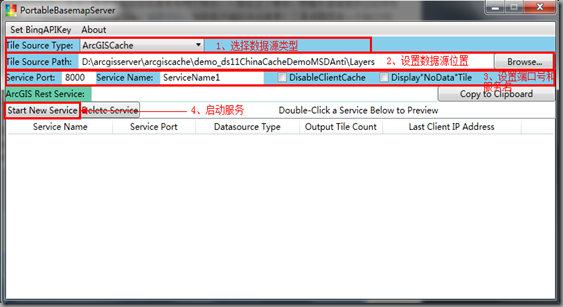
(2)使用Portable Basemap Server,这是一个免安装的WPF程序,来加载各种数据源作为底图图层,直接为更多的客户端API提供一致风格的REST底图服务,从而使开发人员免去为每个应用程序自定义图层的麻烦。具体内容可以查看这里。
使用如下:

直接使用Rest接口访问即可,前端代码如下:
         <esri:Map x:Name="MyMap">
             <!--<esri:Map.Layers>
                 <open:OpenStreetMapLayer ID="MyLayer"></open:OpenStreetMapLayer>
             </esri:Map.Layers>-->
             <esri:ArcGISTiledMapServiceLayer Url="http://10.10.83.95:7080/PBS/rest/services/GoogleMapsRoad/MapServer" ></esri:ArcGISTiledMapServiceLayer>
         </esri:Map>
(3)当在做水文,气象等专题GIS时需要使用google的地形图,这里使用暖风无敌的方法,ArcGIS API for Silverlight 中的ArcGISTiledMapServiceLayer图层,继承自TiledMapServiceLayer。如果想实现自己的缓存地图图层,继承它并重载GetTileUrl方法就可以了。ArcGIS API for Silverlight 内部会计算当前访问的缩放等级level,切片二维编号row,col。这些参数暴露给GetTileUrl方法,在这个方法里面设置访问google静态地图的Url地址。
首先建立一个名为”GoogleTopographicLayer“的类
using System;
using System.Net;
using System.Windows;
using System.Windows.Controls;
using System.Windows.Documents;
using System.Windows.Ink;
using System.Windows.Input;
using System.Windows.Media;
using System.Windows.Media.Animation;
using System.Windows.Shapes;
using ESRI.ArcGIS.Client;
using ESRI.ArcGIS.Client.Geometry;

namespace GoogleMap.CommonClass
{
    public class GoogleTopographicLayer: TiledMapServiceLayer
    {
        private const double cornerCoordinate = 20037508.3427892;
        private string _baseURL = "t@128"; //google地形图

        public override void Initialize()
        {
            ESRI.ArcGIS.Client.Projection.WebMercator mercator = new ESRI.ArcGIS.Client.Projection.WebMercator();
            this.FullExtent = new ESRI.ArcGIS.Client.Geometry.Envelope(-20037508.3427892, -20037508.3427892, 20037508.3427892, 20037508.3427892)
            {
                SpatialReference = new SpatialReference(102100)
            };
            //图层的空间坐标系
            this.SpatialReference = new SpatialReference(102100);
            // 建立切片信息,每个切片大小256*256px,共16级.
            this.TileInfo = new TileInfo()
            {
                Height = 256,
                Width = 256,
                Origin = new MapPoint(-cornerCoordinate, cornerCoordinate) { SpatialReference = new ESRI.ArcGIS.Client.Geometry.SpatialReference(102100) },
                Lods = new Lod[16]
            };
            //为每级建立方案,每一级是前一级别的一半.
            double resolution = cornerCoordinate * 2 / 256;
            for (int i = 0; i < TileInfo.Lods.Length; i++)
            {
                TileInfo.Lods[i] = new Lod() { Resolution = resolution };
                resolution /= 2;
            }
            // 调用初始化函数
            base.Initialize();
        }

        public override string GetTileUrl(int level, int row, int col)
        {
            string url = "http://mt" + (col % 4) + ".google.cn/vt/lyrs=" + _baseURL + "&v=w2.114&hl=zh-CN&gl=cn&" + "x=" + col + "&" + "y=" + row + "&" + "z=" + level + "&s=Galil";
            if (_baseURL == "s@92")
            {
                 url = "http://mt" + (col % 4) + ".google.cn/vt/lyrs=" + _baseURL + "&v=w2.114&hl=zh-CN&gl=cn&" + "x=" + col + "&" + "y=" + row + "&" + "z=" + level + "&s=Galil"; //加载Google遥感图
            }
            if (_baseURL == "t@128")
            {
                url = "http://mt" + (col % 4) + ".google.cn/vt/lyrs=" + _baseURL + ",r@169000000&v=w2.114&hl=zh-CN&gl=cn&" + "x=" + col + "&" + "y=" + row + "&" + "z=" + level + "&s=Galil";//加载Google地形图
             }
            if (_baseURL == "m@161000000")
            {
                url = "http://mt" + (col % 4) + ".google.cn/vt/lyrs=" + _baseURL + "&v=w2.114&hl=zh-CN&gl=cn&" + "x=" + col + "&" + "y=" + row + "&" + "z=" + level + "&s=Galil"; //加载Google街道图
            }
            return string.Format(url);

            //调用加载初始的Google街道地图
            //string baseUrl = "http://mt2.google.cn/vt/v=w2.116&hl=zh-CN&gl=cn&x={0}&y={1}&z={2}&s=G";
            //return string.Format(baseUrl, col, row, level);
        }
    }
}

//以上显示的Google地图类型,有三种,根据需要,可以修改变量_baseURL的初始值即可。
Silverlight项目中的MainPage.xaml文件内容如下:
<UserControl x:Class="GoogleMap.MainPage"
    xmlns="http://schemas.microsoft.com/winfx/2006/xaml/presentation"
    xmlns:x="http://schemas.microsoft.com/winfx/2006/xaml"
    xmlns:d="http://schemas.microsoft.com/expression/blend/2008"
    xmlns:mc="http://schemas.openxmlformats.org/markup-compatibility/2006"
    mc:Ignorable="d"
    xmlns:esri="http://schemas.esri.com/arcgis/client/2009"

    xmlns:sdk="http://schemas.microsoft.com/winfx/2006/xaml/presentation/sdk"
    d:DesignHeight="300" d:DesignWidth="400" Loaded="UserControl_Loaded">

    <Grid x:Name="LayoutRoot" Background="White">
        <esri:Map x:Name="myMap"  IsLogoVisible="False" ZoomDuration="0:00:02" PanDuration="0:00:02">
        </esri:Map>
    </Grid>
</UserControl>
后台代码如下:
using System;
using System.Collections.Generic;
using System.Linq;
using System.Net;
using System.Windows;
using System.Windows.Controls;
using System.Windows.Documents;
using System.Windows.Input;
using System.Windows.Media;
using System.Windows.Media.Animation;
using System.Windows.Shapes;
using TestDZX.CommonClass;
using ESRI.ArcGIS.Client.Geometry;
using ESRI.ArcGIS.Client;

namespace GoogleMap
{
    public partial class MainPage: UserControl
    {
        ESRI.ArcGIS.Client.Projection.WebMercator mercator = new ESRI.ArcGIS.Client.Projection.WebMercator();

        public MainPage()
        {
            InitializeComponent();
        }

        private void UserControl_Loaded(object sender, RoutedEventArgs e)
        {
            GoogleTopographicLayerlayer = new GoogleTopographicLayer();
            myMap.Layers.Add(layer);
        }
    }
}
希望更多地GISER能够在园子里相互交流,学习。我也会不断努力,将我所知道的分享给大家,有啥不对的地方请大家指正!